- Grand Rapids braces for rain and snow this Thanksgiving week, as the National Weather Service warns of potential travel disruptions and lake-effect snow.
- Rain showers today, snow midweek, and frigid lake-effect conditions for the holiday weekend in Southeast Michigan.
- Snow accumulations, lake-effect flurries, and sub-freezing temperatures will impact Michigan’s Upper Peninsula during the Thanksgiving week.
Michigan Thanksgiving Week Weather
Consolidated Thanksgiving Week Michigan Weather Report
Grand Rapids, Detroit & Marquette, MI — Issued by the National Weather Service at 3:09 AM on November 25, 2024. – Showers Today, Snow Wednesday Night, and Lake-Effect Blizzard on Friday. Winter Weather Advisories Issued as UP Braces for Up to 6 Inches of Snow
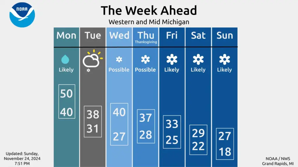
Western Michigan Gets Multiple Rounds of Showers to Persist Through Tuesday Morning

Periods of light rain showers are expected to blanket Grand Rapids and surrounding areas today and into Tuesday morning. A low-pressure system moving from Iowa is set to enhance moisture and instability, producing intermittent rain across the region. Rain will subside Tuesday morning, but patchy showers could linger near U.S. Highway 10 as cooler air moves in.
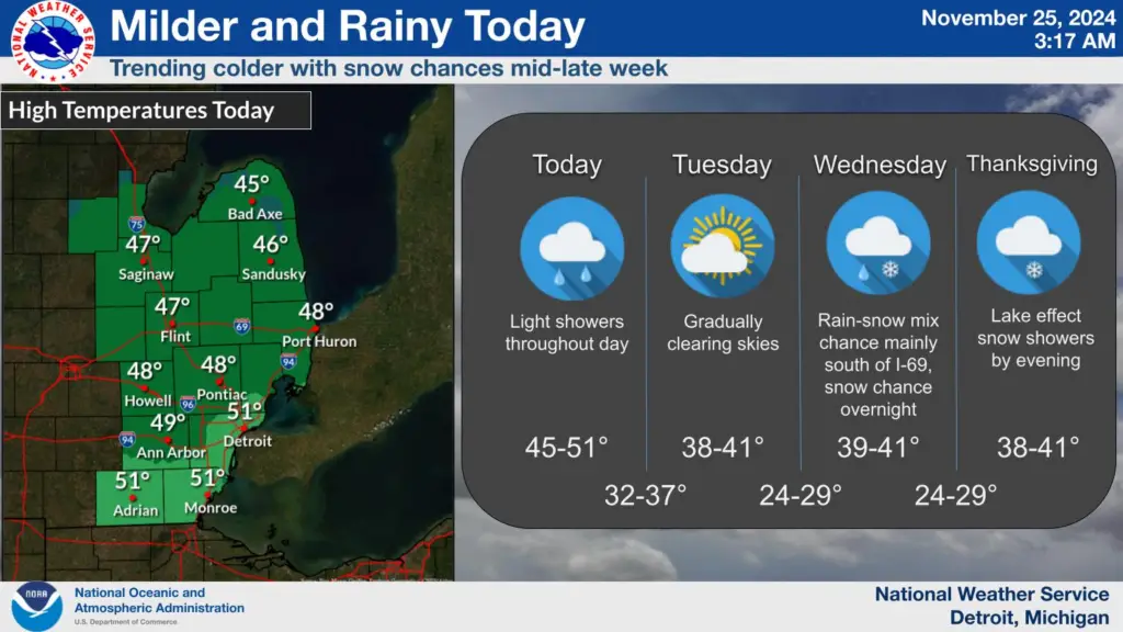
Showers Begin Today with Colder Temperatures on the Way For Southeast Michigan

A low-pressure system tracking across western Illinois will bring rain showers to Southeast Michigan today and into the evening. The rain is expected to intensify during the afternoon as a warm front passes through. High temperatures will climb modestly compared to recent days, but the region will see a rapid shift to colder conditions overnight as the low exits and a cold front arrives.
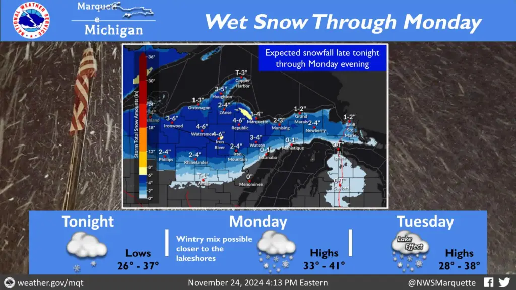
Significant Snowfall Hits the Upper Peninsula Today

A Winter Weather Advisory is in effect for much of the Upper Peninsula as 3 to 6 inches of snow is expected across the region through this evening. Precipitation, which began early this morning, is spreading northward and could mix with rain near Lake Michigan’s shorelines.
- Travel Impact: Slippery conditions are likely during both morning and evening commutes.
- Snow Totals: Interior areas will see the heaviest accumulation, while shoreline regions will experience reduced totals.
Thanksgiving Travel Plans Could Be Disrupted by Snow
A second weather system will approach Wednesday, potentially complicating the busiest travel day of the year. While most of the snow will stay concentrated over Northern Indiana and Ohio, southern Michigan counties may still see light accumulations.
- Timing: Snowfall is likely to begin Wednesday night and may taper off by Thanksgiving morning.
- Impact: While the bulk of the system’s snowfall will occur after dark, travelers are urged to stay alert to changing conditions.
West Michigan – Lake-Effect Snow to Follow Thanksgiving Holiday
Colder air masses will surge into the region Thursday night, setting the stage for intense lake-effect snow showers on Friday. Temperatures at 850 mb altitude are predicted to plummet between -11 and -13°C, creating ideal conditions for significant snowfall.
- Areas Affected: Shoreline regions and the southwest quadrant of Michigan will bear the brunt of this event.
- Forecasted Accumulation: Advisory-level snowfall is likely, potentially disrupting post-holiday travel.
Another break is expected Saturday, but models suggest renewed lake-effect activity by Saturday night, which could persist into early next week.
Southeast Michigan – Light Snow Expected Midweek as Travel Peaks
As families prepare for Thanksgiving, an incoming system on Wednesday night could bring light snow to Southeast Michigan, with areas south of Detroit likely to see the most accumulation.
- Timing: Snowfall is expected to begin late Wednesday and taper off by early Thursday.
- Impact: While snowfall amounts are uncertain, the timing could impact pre-Thanksgiving travel.
Forecast models currently show variation in snowfall amounts, with some ensembles predicting limited snow and others suggesting a more significant swath. Travelers are urged to stay informed of updates.
Upper Peninsula – Lake-Effect Snow Will Dominate the Rest of the Week
After the system snow departs tonight, the region will transition into an active lake-effect snow pattern. This is expected to persist over the northwest to west-northwest snow belts for the next seven days, delivering several inches of fluffy snow in localized bands.
- Tuesday: Winds of up to 35 mph along the Lake Superior shoreline could produce heavy snow rates exceeding 2 inches per hour in some bands.
- Late Week: Renewed lake-effect snowfall on Thursday and Friday will bring additional accumulations to favored areas.
- Chilly Thanksgiving and Beyond – Temperatures will plummet below seasonal averages starting Thursday, with daytime highs below freezing across the region and nighttime lows in the teens. This cold pattern is expected to continue into the first week of December, keeping the Upper Peninsula locked in a wintery grip.
Today’s Forecast:
West Michigan
Expect overcast skies with highs near 48°F. Rain showers will persist through the evening, gradually transitioning into light snow after midnight as temperatures fall below freezing.
Southeast Michigan
Expect rain showers throughout the day, with highs in the low 50s. Rain will transition to a mix of light snow and flurries overnight as temperatures drop into the 30s.
Upper Peninsula
Snow continues throughout the day, with highs in the low 30s. Accumulations will reach 3 to 6 inches by evening, with light winds shifting northwest overnight.
Hazardous Weather Changes Fast – Stay Updated
Weather Watches, Warnings, and Advisories are frequently updated by the NWS. Please look for updates to this report from the National Weather Service, your local news channels, and NOAA All Hazards radio. Follow ThumbWind Publications for more local weather and news updates. Your helpful comments are welcome.
More Weather Stories
14 Areas Around the Great Lakes With Significant Lake Effect Snow – How Does it Happen – Besides Buffalo New York, these 14 areas around the Great Lake region are particularly prone to getting Lake Effect Snow (LES). We review each location in detail
4 Live Venice Florida Webcams, Latest Venice News & Weather Updates – Florida is known for its beautiful beaches and friendly people. We have a live Venice, Florida, Webcam so that you can see the beach’s traffic and weather in real time.
Great Lakes Ice Coverage – Ice coverage over the Great Lakes is a huge factor in weather patterns over the region and an indicator of future lake levels. ThumbWind consolidates and summarizes the Great Lakes ice cover from US and Canadian agencies and presents it on this single page.


