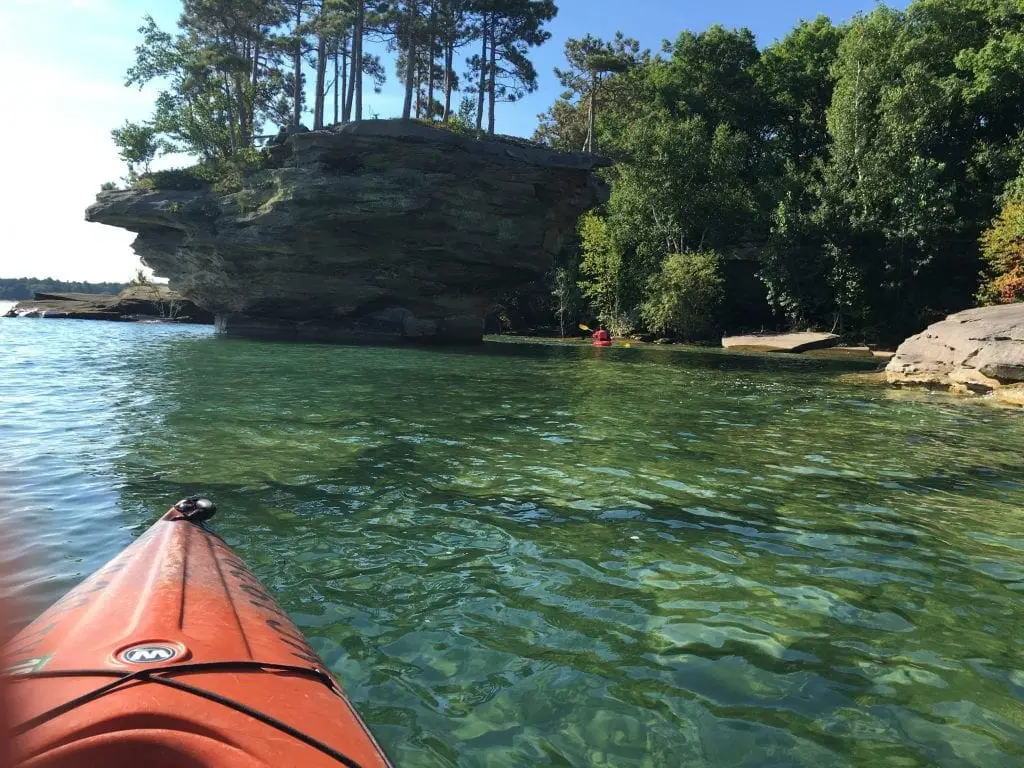
One of the most amazing sites in the Upper Thumb is Turnip Rock. Considered one of the ten most beautiful places in Michigan. Carved over time by the force of constant wave action, the soft limestone has been shaped to its namesake and separated from the mainland over thousands of years.
Turnip Rock Michigan Is Internationally Known
CNN called it one of the Most Amazing Rock Formations in America, and Pure Michigan featured it on its 2016 magazine cover. International travelers entering Detroit Metropolitan Airport see Turnip Rock as their first view of Michigan’s scenes at the tip of the thumb coming into customs. It’s a marvel to behold, and it’s an easy Port Austin kayak trip if the conditions are right.
#7 Turnip Rock is an Easy Paddle

Paddling to turnip rock is not hard. Located at the tip of Michigan’s thumb, the rock formation is located near Port Austin, Michigan. It’s about a four-hour round trip from Port Austin. This small guide offers a local point of view to avoid problems with local law enforcement and property owners while enjoying a unique natural wonder.
#6 Turnip Rock is on Private Property
Despite its uniqueness, this natural wonder is located and owned by the Pointe Aux Barques Cottage Community and is private land. Thus the only way to see the rock formation is from the water. Fortunately, that can easily be achieved by canoe or kayak. This means that you can’t go feet dry. Stay in the water. The area around the rock is monitored, and even the topic of an Instagram account. If you must get out of our kayak, stay as close to the water’s edge as possible. (Unless its an emergency)
#5 Paddling Near Turnip Rock on Busy Weekends – What To Do
During the weekends, the number of paddlers can get quite large. If the area around the rock is crowded, consider paddling a few hundred yards past the rock and view the overhangs and cave features that border the Pointe Aux Barques community. During the late 1800s, the caves were hideouts for fugitives. It’s worth taking a few minutes to explore. You may be tempted to leave your kayak and climb the rocks for a view. This is a no-no, and several signs remind us not to trespass. (IMHO, these signs are obtrusive and possibly illegal as they are posted under the high water mark of Lake Huron)

#4 Heed Weather and Travel Time to Turnip Rock

Plan on two to four hours travel time to kayak to Turnip Rock from Port Austin. This assumes that the winds and lake are calm. You will paddle northeast along the shallow coastline until you see the small cliffs that mark the start of Pointe Aux Barques. If the wind is strong and the lake is wavey, it’s wise to defer to another day. Southern winds pushed Novice paddlers out into the lake, requiring assistance or rescue.
Port Austin Kayak, affectionately called the PAK, offers daily tweets of weather conditions. It’s prudent advice to heed their recommendations when considering a trip out to Turnip Rock or along the tip of the Thumb shoreline.
We will continue to post the weather conditions directly on our website https://t.co/AqGFre3hiW
— portaustinkayak (@portaustinkayak) August 4, 2023
If you have booked a trip or are planning to paddle out to Turnip Rock, it’s a best practice to monitor the PAK feed. If they are not renting,, it is wise to stay off the lake that day.
#3 Can I Climb on Turnip and Fingernail Rocks?
Despite numerous YouTube and other postings showing people climbing all over the rock formation, you are urged not to. The shore formations above the high water mark are private property. People have been hurt trying to climb it and arrested for trespass. Also, the stone is rather fragile and prone to breakage and collapse. The best way to mark your visit is to capture the rock formation with digital photos of you and your peeps in unique light and weather. Stay wet and wild and get a great shot from the water.

#2 What to Bring on Your Port Austin Kayak to Turnip Rock
When kayaking to Turnip Rock, bring a life jacket, sunglasses, sunscreen, a small towel, cell phone, and a dry bag. Bring a Nalgene of water and something to munch on. Water shoes are also highly recommended. It’s not a strenuous trip, but winds and weather can make kayaking a challenge for the unprepared.
#1 Leave No Trace Kayaking to Turnip Rock

Leaving no trace is everyone’s responsibility. While doing a Port Austin kayak trip to turnip rock remember to minimize your impact so it can be enjoyed for the next generation. Here are the seven principles of Leave No Trace.
- Plan Ahead and Prepare. …
- Travel and Camp on Durable Surfaces. …
- Dispose of Waste Properly (Pack It In, Pack It Out) …
- Leave What You Find. …
- Minimize Campfire Impacts. …
- Respect Wildlife. …
- Be Considerate of Other Visitors
FAQ Turnip Rock Port Austin
How long does it take to paddle to Turnip Rock?
Is the route to Turnip Rock easy?
Can I get out and climb onshore or up on Turnip Rock?
However, you may also traverse the area below the “ordinary high watermark.” This doesn’t mean you can set up camp, but you can stretch your legs, swim, and take pictures. Don’t make a nuisance of yourself. Don’t try climbing up the rocks. The area is literally steps away from the residential homes and cottages of Pointe Aux Barques. Use Leave No Trace principles.
What should I bring with me to Turnip Rock?
Are there tour boats taking visitors out to see Turnip Rock?
Related Reading About Port Austin Kayak to Turnip Rock
See A Drone Tour of Turnip Rock – This drone flyby of Turnip Rock was made by a Kaioshin Supreme. This couple was kayaking on a very quiet and wave-free afternoon at Pointe Aux Barques. It’s an interesting perspective.
Michigan’s Thumb Sparkles in Late Summer – My favorite time to be in Michigan’s Thumb. The Caseville Cheeseburger Festival has long since passed. The Labor Day weekend has come and gone. Things are quieter. I can now cross M-25 over the beach in silence and without fear. Fall is a great season.
Time Lapse…30 Years of Growth in Michigan’s Thumb – Amazingly, you can now see how Michigan’s Upper Thumb region has changed in the past 30 years. Google’s Earth Engine gives a global time-lapse view built from annual composites of Landsat satellite images. Watch the growth of Michigan’s Thumb across Huron County’s landscape beginning as early as 1984.
Great Lakes Ship Travel in the 1800s – In the days before the highway and autos, the only way to travel the vast distances for the Great Lakes was by sail and steamer. In the mid-1800s until well into the 1950s one could travel most of the lakes in style and comfort.
Haunted and Spooky Sites in Michigan’s Thumb – Michigan’s Upper Thumb is full of colorful history—from the boomtowns of the 1800s lumber era to the resorts and vacation homes of today. The area has long been acknowledged as an active paranormal region and has been the subject of books, film, and television.


