Michigan sees snow squalls in the Southeast, heavy lake-effect snow in Northern regions, and 3-foot drifts in the Upper Peninsula through Sunday.
Michigan Divided by Lake Effect Snow and Dangerous Whiteout Conditions
— Issued by the National Weather Service at 3:44 AM on November 29, 2024.
Snow Squalls Threaten Southeast Michigan Travelers

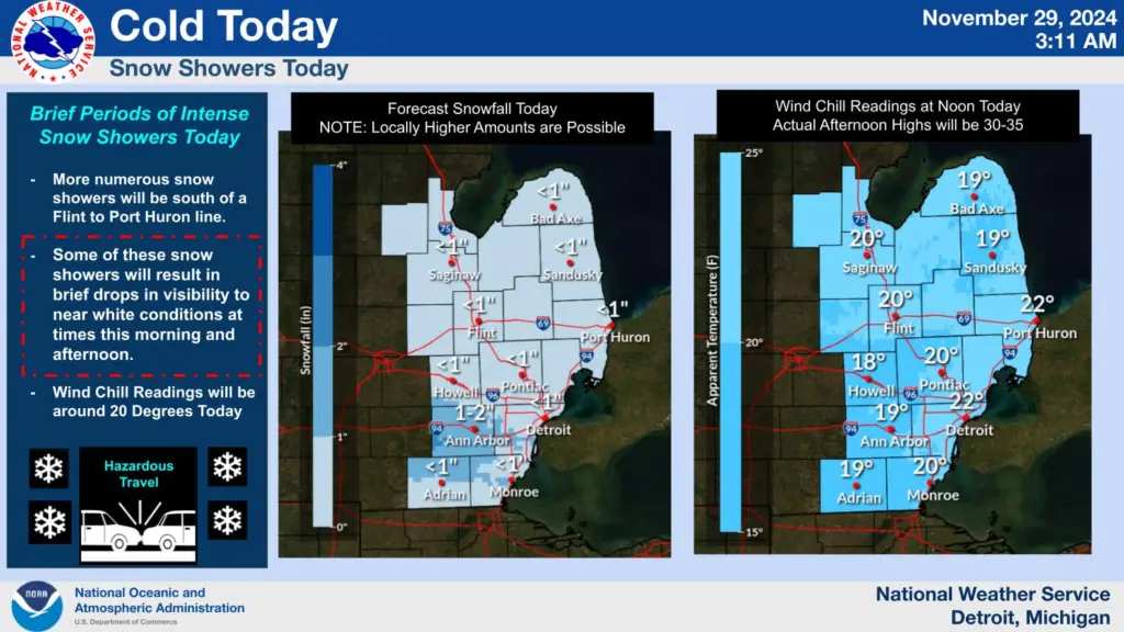
Southeast Michigan is bracing for scattered snow squalls through Friday evening, causing hazardous whiteout conditions and highly variable snowfall totals. The National Weather Service predicts 1-4 inches of snow, with localized areas south of the M-59 corridor potentially seeing 2-4 inches under persistent snow bands. Visibility could drop to near zero during snow squalls, creating dangerous driving conditions.
Temperatures will remain below freezing, with wind chills in the teens, as 30 mph gusts exacerbate the wintery bite. Travelers along I-96 and southward toward the Michigan-Ohio border are advised to exercise caution.
Northern Lower Michigan: Up to 20 Inches Expected

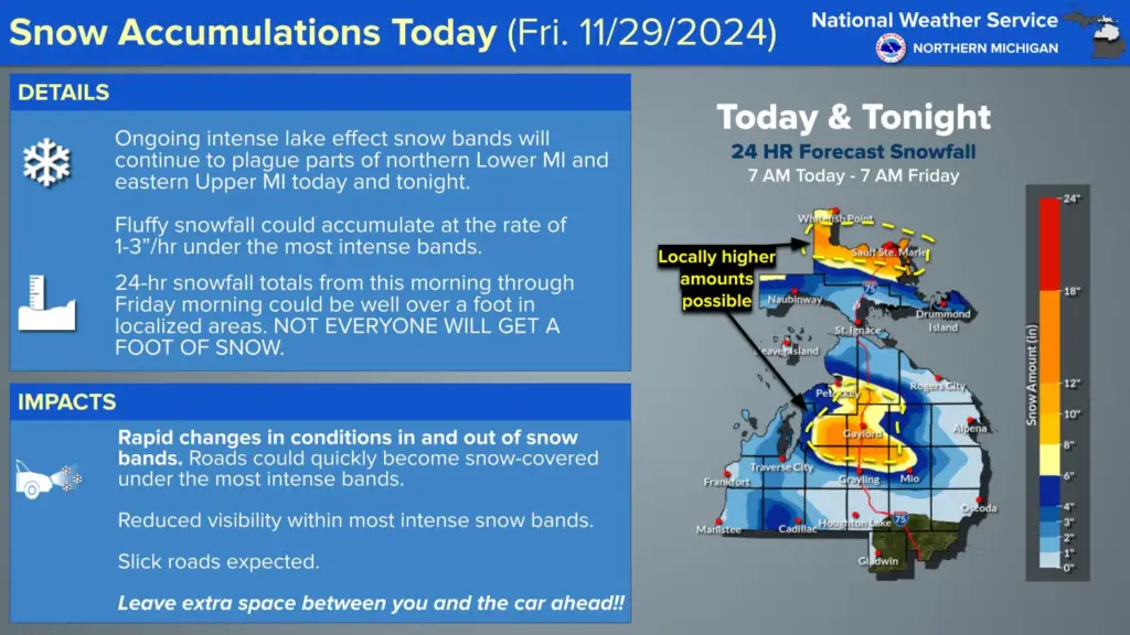
Northern Lower Michigan is seeing prolonged, moderate-to-heavy lake effect snow through the weekend. Areas between Gaylord and Kalkaska could receive over a foot of snow by Saturday morning, with snowfall totals in the Upper Peninsula and eastern sectors possibly nearing 20 inches by Sunday.
Winds shifting to the west-northwest will drive snow bands through the snowbelt regions, with rates exceeding 1 inch per hour in spots. The National Weather Service has issued Winter Storm Warnings across much of the region, urging travelers to delay plans as roads become treacherous.
Upper Peninsula Hit Hard: Multi-Day Whiteouts and 3-Foot Drifts

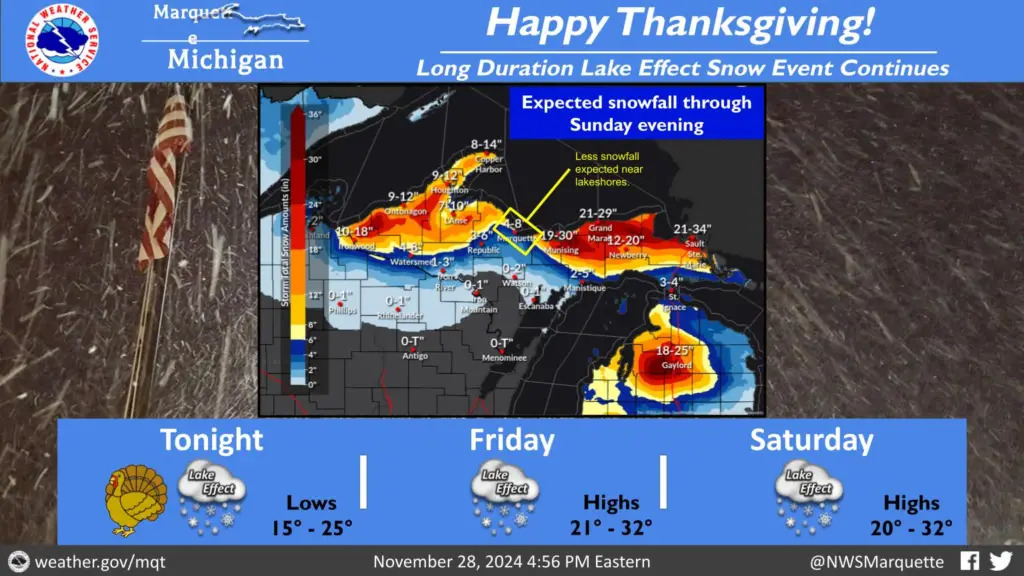
The Upper Peninsula is bearing the brunt of this system, with some areas expecting 1-3 feet of snow by Monday morning. The heaviest snowfall is concentrated in the northwest snow belts, including the Porcupine Mountains and areas north of Munising. Gusty winds up to 30 mph are creating significant blowing and drifting snow, reducing visibility and adding to the hazards.
Winter Storm Warnings are extended through Sunday for eastern portions of the Upper Peninsula, where the long fetch across Lake Superior amplifies snowfall rates. The NWS emphasizes extreme caution, as icy roads and whiteout conditions persist through the weekend.
Hazardous Michigan Weather Changes Fast – Stay Updated
Weather Watches, Warnings, and Advisories are frequently updated by the National Weather Service. Please check local forecasts and NOAA All Hazards Radio for the latest information. For additional updates, follow ThumbWind Publications for Michigan weather and news.
Check Out Our Weather Related Features
- Climate Twins – Countries with Weather Similar to Michigan
Curious about which places share Michigan’s unique weather? Explore surprising parallels and key differences in global climate comparisons. - Live Webcams Of 7 Lake Effect Snow Cities Around The Great Lakes
Watch how snow transforms cities into winter wonderlands in real time through our curated live webcam list. - 14 Areas Around the Great Lakes With Significant Lake Effect Snow – How Does it Happen
Learn how the Great Lakes produce their signature snowfalls and which areas see the heaviest accumulation.
Your Turn – Like This, or Hate it – We Want To Hear From You
Please offer an insightful and thoughtful comment. Idiotic, profane, or threatening comments are eliminated without remorse. Consider sharing this story. Follow us to have other feature stories fill up your Newsbreak feed from ThumbWind Publications.


