A biting arctic air mass brings heavy lake effect snow and hazardous travel to Michigan this weekend, with up to two feet possible in some areas.
Snow Squalls and Arctic Winds Slam Michigan; Hazardous Travel Ahead
DETROIT — Issued by the National Weather Service at 3:00 AM EST on November 28, 2024.
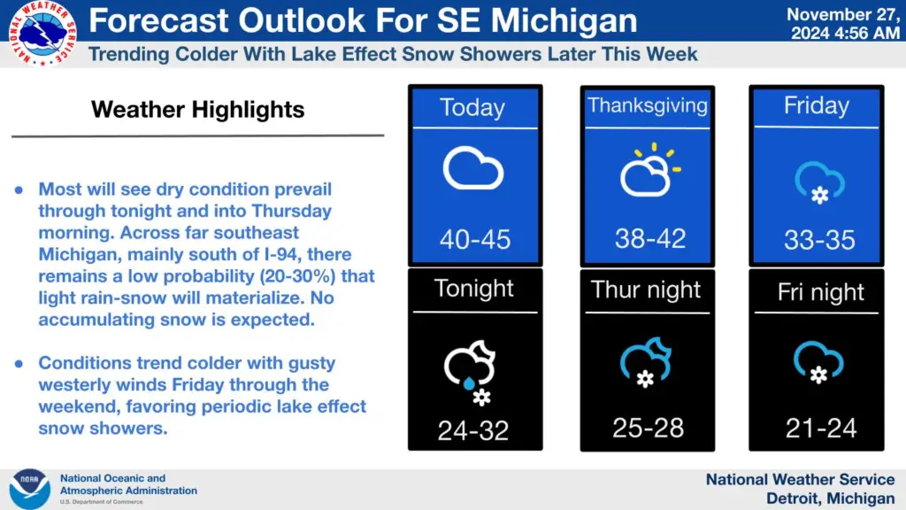
Snow Showers and Arctic Air Dominate Thanksgiving Weather

Southeast Michigan will experience dry conditions and temperatures peaking in the upper 30s to 40°F this Thanksgiving, offering a brief respite before frigid weather sets in. As a low-pressure system exits toward the Northeast, arctic air descends into the region tonight, driving temperatures 5–10°F below seasonal averages.
By Friday, lake effect snow showers will intensify, especially along the I-94 corridor, as the cold air interacts with the relatively warm Great Lakes.
Snow Squalls Could Bring Whiteout Conditions Friday in Southeast Michigan
Expect hazardous travel as snow squalls develop Friday afternoon, with near-zero visibility and wind gusts exceeding 30 mph. These squalls are most likely south of M-59, with some extending into the M-59 to I-69 corridors. Localized snowfall totals could reach 2–3 inches in squall-affected areas, while general accumulations of 1–2 inches are expected.
Hazardous Holiday Weekend Travel Expected Across Northern Michigan

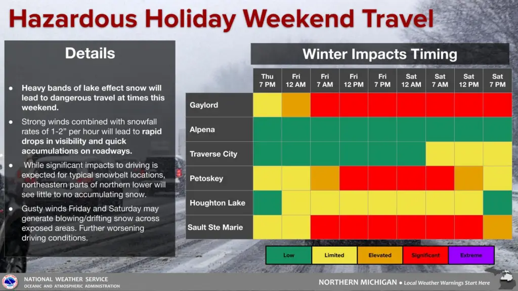
As the lake effect snow event intensifies, Northern Michigan residents and travelers are urged to prepare for dangerous road conditions throughout the holiday weekend.
Key Winter Weather Impacts
- Heavy Snow Bands: Snowfall rates of 1–2 inches per hour will cause quick accumulations on roads and drastically reduced visibility.
- Strong Winds: Gusty conditions Friday and Saturday may result in blowing and drifting snow, particularly in exposed areas, further impairing travel.
- Localized Impacts: While significant snow is expected in traditional snowbelt areas, northeastern Lower Michigan, including Alpena, will see limited or no accumulations.
Timing and Areas of Concern
The timing chart highlights when and where the most hazardous conditions will occur:
- Gaylord, Petoskey, and Sault Ste. Marie: Significant to extreme travel impacts expected starting late Thursday, peaking Friday, and continuing through Saturday evening.
- Traverse City and Houghton Lake: Limited impacts early Friday but increasing to elevated by Saturday due to intermittent snow and wind.
- Alpena: Low impacts throughout the weekend, with little to no accumulating snow.
Travel Safety Tips
Motorists are advised to:
- Monitor live weather updates from the National Weather Service.
- Avoid travel during peak snow and wind periods.
- Ensure vehicles are equipped for winter conditions, including emergency kits.
Heaviest Snowfall Targets Northwest Lower Michigan and Upper Peninsula
Northwest winds will drive significant lake-effect snow across northwestern Lower Michigan and the eastern Upper Peninsula, where Winter Storm Warnings are in effect. Areas such as Gaylord, Mancelona, and Paradise may receive 12–24 inches of snow through Saturday.
Lake effect snow in these regions will feature 1–3 inch per hour snowfall rates, strong winds, and dangerous visibility reductions. Travel along M-28 and other major routes will be severely impacted.
Winter Storm Watches Expand Across Northwest Snow Belts

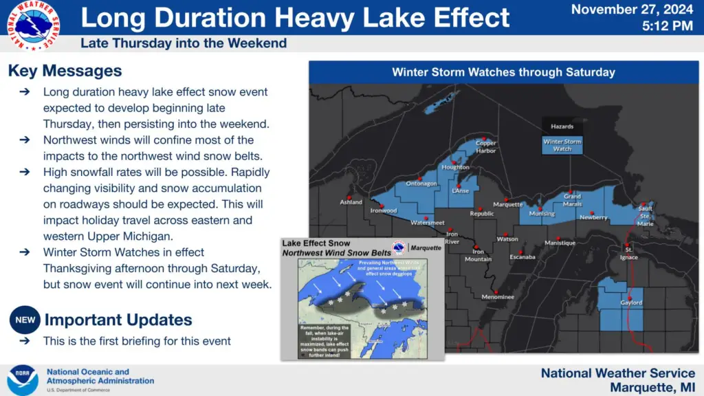
Upper Michigan braces for a long-duration lake effect snow event beginning late Thursday and persisting through the weekend. Winter Storm Watches are in effect across much of the region, particularly in the northwest wind snow belts, where snowfall rates and accumulations are expected to peak.
Key Impacts Expected Through the Weekend
- Heavy Snowfall: Accumulations exceeding a foot in some areas, with the heaviest totals likely near Munising, Grand Marais, and the Houghton highlands.
- Hazardous Travel Conditions: Rapidly changing visibility and slick roads will make holiday travel treacherous, particularly along M-28 and U.S. 41.
- Northwest Winds: Persistent winds will enhance lake effect snow production, focusing the impacts within the northwest wind belts.
Snow Belts Face Prolonged Impact
The northwest wind flow will funnel heavy snow bands inland, targeting areas downwind of Lake Superior. Residents in affected zones are urged to prepare for rapidly deteriorating conditions and potential travel delays. Snowfall rates in these bands could reach 2–3 inches per hour, creating near-whiteout conditions at times.
Weekend Forecast: Snow, Cold, and More Snow
Lake effect snow showers will persist into the weekend, albeit with reduced intensity. Saturday and Sunday will see temperatures hovering near freezing, with scattered light snow showers possible across the region. Long-range forecasts indicate continued snowfall and sub-freezing highs through early next week.
Hazardous Weather Changes Fast – Stay Updated
Weather Watches, Warnings, and Advisories are frequently updated by the National Weather Service. Please look for updates to this report from your local news channels and NOAA All Hazards radio. For more updates, follow ThumbWind Publications.
Check Out Our Weather-Related Features
- Climate Twins – Countries with Weather Similar to Michigan
Curious about which places on Earth share Michigan’s unique weather patterns? Dive into Michigan’s Climate Twins to explore surprising similarities. - Live Webcams of 7 Lake Effect Snow Cities Around the Great Lakes
Experience the enchanting transformation of urban landscapes into winter wonderlands with heavy snowfall in snowbelt cities. - 14 Areas Around the Great Lakes With Significant Lake Effect Snow – How Does it Happen
Discover the science behind lake effect snow and the regions most affected by it around the Great Lakes.
Your Turn – Like This, or Hate it – We Want To Hear From You
Please offer an insightful and thoughtful comment. Idiotic, profane, or threatening comments are eliminated without remorse. Consider sharing this story. Follow us to have other feature stories fill up your Newsbreak feed from ThumbWind Publications.


